One of my favorite hikes, the Canyon View Loop Trail at the Whitewater Preserve, between Palm Springs and Joshua Tree, offers beauty at every twist and turn. The well-marked trail follows the Whitewater River Canyon until it reaches the iconic PCT and then climbs up to a bluff that offers non-stop views into the canyon and high peaks of the San Gorgonio Wilderness Area. It's a hike that's worth making a trip for, so give it a try.
Where is Whitewater Preserve?
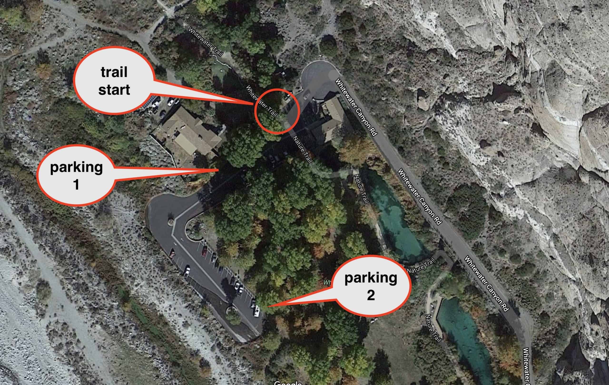
Whitewater Preserve is a few miles up the Whitewater River from Interstate 10. The hike starts from the visitor's center area, which also offers bathrooms and picnic tables. Unlike most hikes where you can show up and hike whenever you want, Whitewater Preserve usually has opening hours and is closed some days to give the wildlife some space. Check the link at the beginning of the guide to confirm the hours.
There's a big parking lot as soon as you pull in.If that lot is full just go straight and there's another, larger parking lot.There are a ton of picnic benches in the shade to chill out and relax at.The Canyon View Loop Trail starts right at the entrance to the Preserve visitor area.
If you park in the lot, take note of the closing time. The gates are locked and you may be stuck in there.
Whitewater Preserve Alternate Parking
There are times when the Whitewater Preserve visitor's area is closed, but the trails are still open. Again, check the link at the top of this guide for the specifics. When this is the case, you can't park at the main lots and have to start the loop hike downs the road from the visitor's center.
The alternate parking is a few minutes down the road from the visitor's center area entrance.The alternate parking area is along the road, just before you cross the river. If you go further up the road, it's all no-parking.
Gear for the Hike
This hike is in the desert, and in the summer, it can get very hot. I recommend going early or in a cooler season and still bringing some sun protection. Bring at least 1L of water for the loop hike. The trail is sandy in places but otherwise very well manicured. I use light hiking gear, but you can get away with fitness clothing.
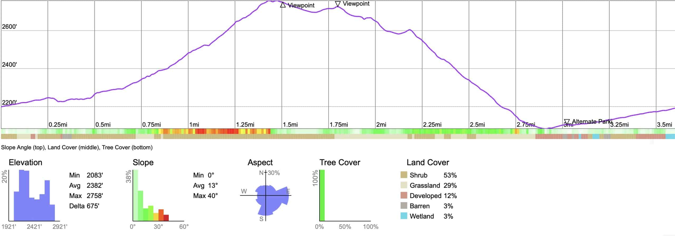
While there's about 700 feet of climbing, if you're in decent shape, it's not a big deal. The climb has switchbacks to make the gradient easier.
3d Map
The first part of the hike follows Whitewater Canyon. You'll then climb up to the top of the bluff on the PCT, and then head back down to finish the loop.
Hike Brief
The area around the visitor center used to be the Whitewater Trout Farm. You can see the trout pools when you start the hike. When it went out of business in 2006, local conservation groups bought the area and it eventually came into the care of the Wildlands Conservancy. Photo circa 1950s from Banning Library District
The Whitewater Preserve is home to endangered peninsular bighorn sheep, bears, coyotes, and mountain lions. Generally you won't see any of these animals, but occasionally, if you keep your eyes open on the hills above you, you may spot a bighorn.
In order to return the land back to its original state, the Wildlands Conservancy has removed old buildings, roads, non-native plants, and has restored the river from a muddy cattle bog to the crystal clear water you see today.
The Whitewater River, which you follow on the hike, starts high in the mountains and flows down to Palm Springs. When it's flooded and raging, the river sometimes flows out into the Salton Sea. Generally the area is closed when flooded, but even the "normal" river levels can be deadly. There is a death from being swept away in the river every few years. Enter the water with extreme caution, if at all.
PCT thru-hikers often make the short detour to camp at the Whitewater Preserve visitor's center area.
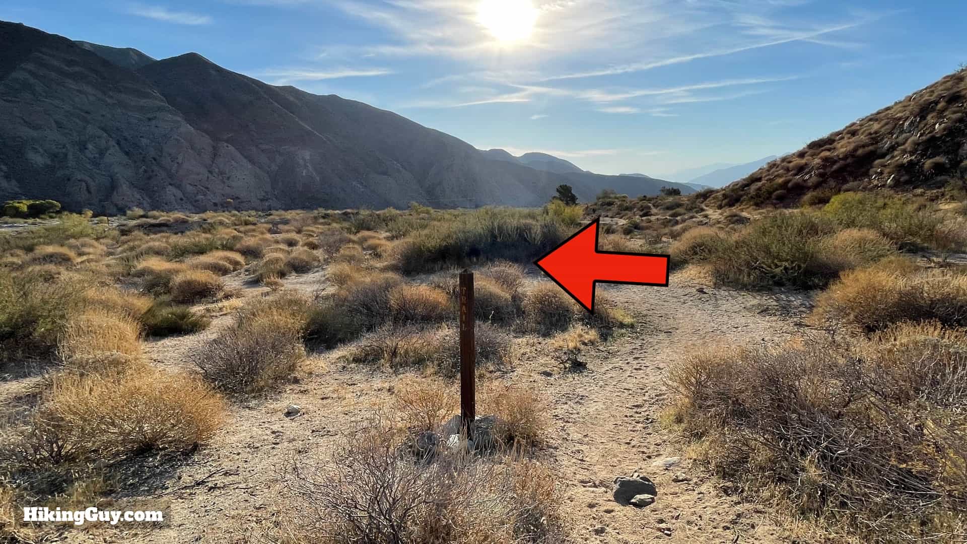
The trailhead is by the entrance to the preserve. Look for the trail board.Read the trail board for any notices and continue on.Continue past the trout pond.Right after that is a neat trail distance sign on a stone, along with an interpretive display just past it.Continue straight down the path, avoiding side trails.When you get to the junction, make the right to continue on the loop trail.Your next landmark is the Pacific Crest Trail in 0.5 miles.Shortly after the last trail sign, make the left at the post to continue on the trail.Follow the trail towards the river and bluffs.You'll cross the river on a few little wooden bridges.Head up this marvelously engineered stone staircase.You'll see a sign letting you know that you're entering the San Gorgonio Wilderness.
When you get to the PCT junction, make the left and start heading uphill.I love that the trail sign has the distance to Canada on it (via the PCT). We're just doing the slightly more modest Canyon View Loop today; three miles to go.Start climbing out of the canyon on the PCT.You'll get some great views into the canyon as you climb.Switchbacks make the effort manageable.You'll head away from the canyon, and if you look closely, you'll be able to see the trail climbing up the hillside and through the notch ahead.At the top, make the left.You made it to the high point! Head straight down the trail. For the next mile or two you'll be treated to nice views.Look for small use trails to the left which offer panoramic views into Whitewater Canyon.Continue on the trail as it heads away from the edge. The big mountain ahead of you is Mt San Jacinto, which you can summit from the bottom (Cactus to Clouds), or with the help of a tram ride.Avoid the side trails on the left for a hot second.Until the main trail swings around and comes to the edge.From here you'll be able to see down into the visitor's center area at Whitewater Preserve.And the lower peaks of the San Gorgonio Wilderness.After you soak in the views, continue down the trail.The trail goes along a fence, which is next to the sheer cliff.And then at the end of the plateau you'll start the descent.Follow the switchbacks downhill to the canyon.Towards the bottom the trail makes a hard left and is marked as such.And then you pop back out on the road. Walk up the road for a few minutes.And look for this marked trail sign on the left after you cross the river. There are a bunch of unofficial paths before this. Go until you see the trail sign.The trail is flanked with stones as it winds its way up the wash. If you're not walking on a path like this, you're not on the official trail.There's a marker half-way up pointing you to the right. And again, the trail is flanked with stones.This part of the hike is really pretty. You'll get nice views of the mountains as you head up the wash.And soon you'll end up back at the parking lot by the visitor's center. That's the hike.