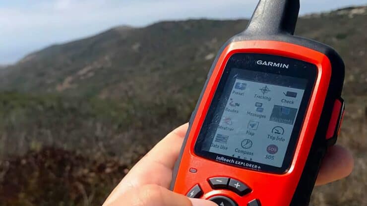

In-Depth Garmin Inreach Explorer Review
The Garmin InReach Explorer (formerly Delorme InReach) is a must-have in your pack. It's satellite functions offer backcountry SOS and non-emergency communications. Its navigation functions have some flaws, but don't get the InReach for that; it's worth the cost just for the messaging and weather features. For a few hundred bucks, the Garmin InReach could save your life. It's a no-brainer.
- What the Garmin InReach Does
- Garmin InReach Explorer+ or SE+?
- Which Garmin InReach Subscription To Get
- Tips On Using the Garmin InReach
I'm using a new satellite communicator now. Check out my latest gear page to see which unit I'm using.
Important Update
A Quick Primer On Why the InReach Is Great
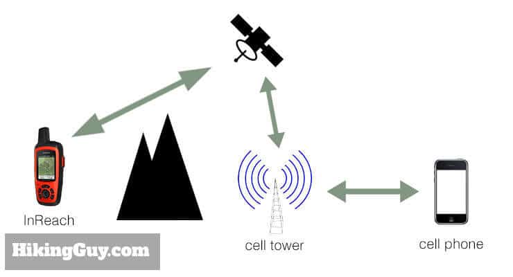
So everyone understands how to send a text message with a cell phone. And if you're hiking, and you have cell phone reception, and are in an emergency, you can call 911 (or text 911) and handle the situation. But what happens when you don't have cell phone reception? That's a common occurrence when you're out hiking in the wilderness. Hell, it's a fairly common occurrence even when not in the wilderness.
That's where the Garmin InReach comes in. The InReach uses satellites to communicate and send and receive text messages. There's no need to be near a cell phone signal. You can be in Antartica, and it works (not confirmed, yet!).
The InReach, which comes in two models, the SE and Explorer, has many other helpful functions as well. Keep reading to see why you need this potentially life-saving device in your pack.
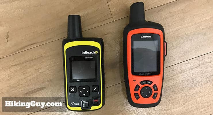
Garmin InReach Explorer+ or SE+?
Garmin sells two flavors of the InReach, and here's the difference. The SE has all the core functions including SOS and two-way texting. The Explorer, which costs about $50 more, adds topo maps, a built-in digital compass, barometric altimeter, and accelerometer.
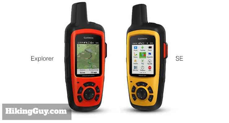
Are the maps and sensors worth the extra $50? Yes, even though I rarely use them. As you read on, you'll find out that the InReach Explorer isn't really a good unit for mapping and navigation. I have other tools that I use for that. I think the extra $50 is a good investment in case of an emergency. If your main GPS fails, you have robust tools in the Explorer's topo maps, elevation, and compass. It should be enough to get you out of a jam. So I spend the extra $50 just in case.
Garmin InReach Subscriptions
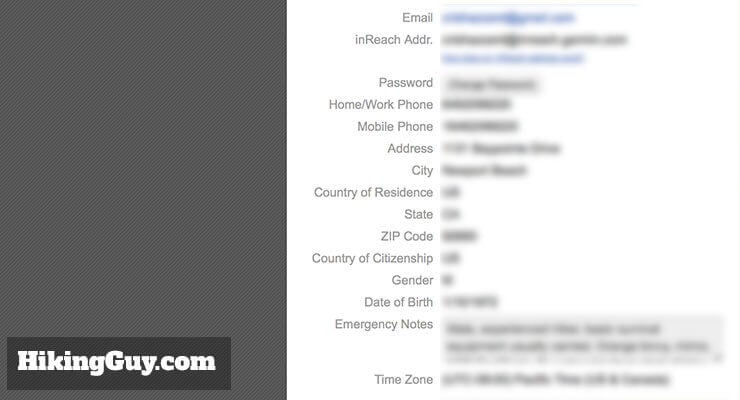
Before we explore the InReach in depth, I want to mention that you need a paid subscription to use the Garmin InReach. I knew that a lot of folks aren't interested paying for a subscription, so if that's you, you can stop reading here.
For me, the small monthly fee is worth it for the peace of mind. When you consider that this device can save your life, $15/month doesn't seem too expensive.
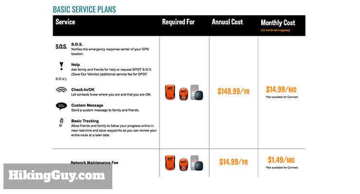
Here are the current service tiers. I use the cheapest Freedom Plan option, which lets me send unlimited preset messages and use the SOS, and it works great. If you get the Freedom Plan, you can turn it off and on at monthly intervals. You can also just get an annual plan for less.
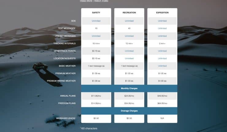
I'll talk about tracking points and location pings later. You probably don't need them, but maybe you do. Read on.
Garmin charges a $20 "activation" fee that you pay once. You can always upgrade your account for free, and if you downgrade, it costs you $25.
I was going camping out in Joshua Tree with friends and was going to not bring my family with me. I found out that there was no cell service. I found this unit since it was able to send and receive messages to your family over satellite. Well, it worked. When everyone had no service, I was keeping in close contact with my wife and kids. I also like the fact that it has SOS. You never know what could happen and want to make sure that communications are there when you need them. I'm glad I purchased this! - REI Reviewer
You can also get business plans for the InReach which support multiple units and teams.
Should You Upgrade From the Delorme InReach
If you weren't aware, Garmin acquired the firm Delorme, which made the original InReach units. In fact, Garmin acquired Delorme simply for the InReach unit, even though Delorme had been creating maps and mapping products for over 40 years. So that's a good sign that the unit and technology is good.
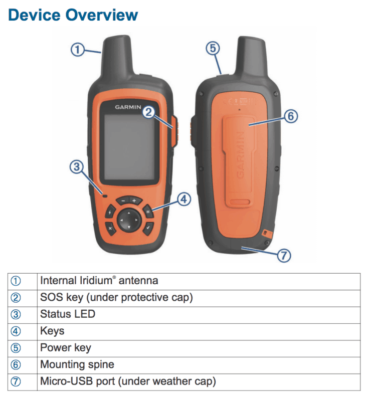
Garmin took about a year to improve the InReach Explorer unit. Garmin addressed a few key flaws in the original Delorme InReach Explorer.
- They enlarged the (old) hard to read screen - from 1.4" x 1.2" inches to 1.75" x 1.5". It might seem like a small change, but it is easier to read.
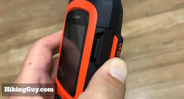
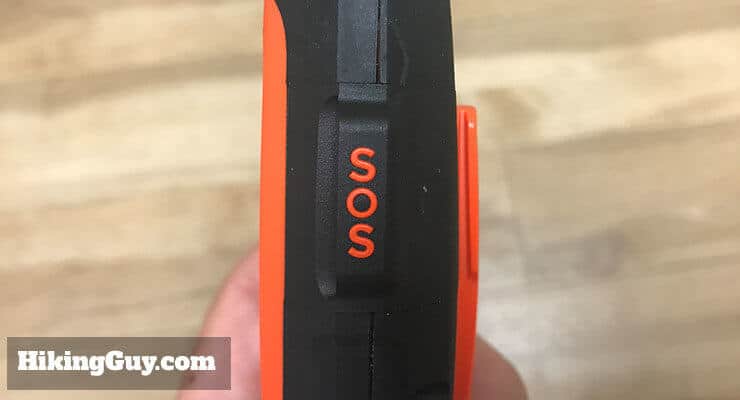
- They improved the keypad. There are a few more buttons, the old lock slide is gone, and the SOS button was moved away from the main keypad and was given a cover to avoid accidentally hitting it.
- They added weather forecasts.
Using the Garmin InReach
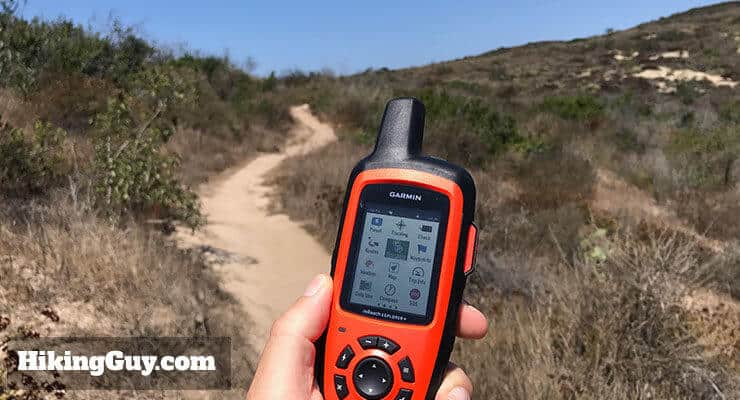
The Garmin Explorer is Easy To Use
To start, I'll walk you through the layout (more on that later too). The buttons are straightforward, and once you use it a few times, become second nature.
I particularly like the fact that the power button is on top and partially protected by the antenna, where it doesn't get pressed accidentally. Same thing with the SOS button. It's the biggest button on the unit, and easy to find if you're hurt, blinded, etc.
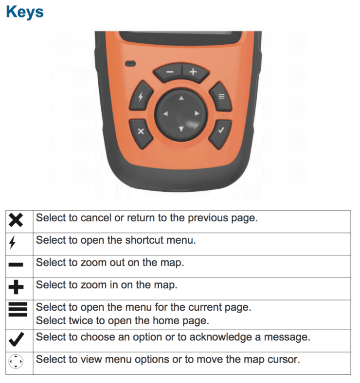
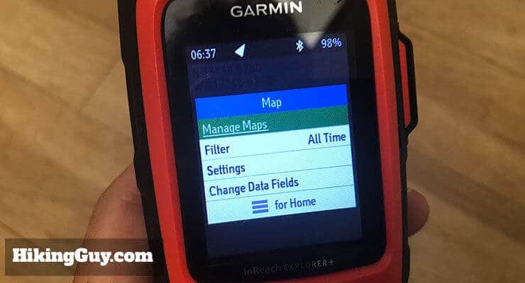
The menu is straightforward, but a bit crowded and dated. Again, once you play with it for a few minutes, it's easy to use. You simply use the rocker button to move through the menu items. The check button puts you into a function; the "x" button backs you out. It's simple.
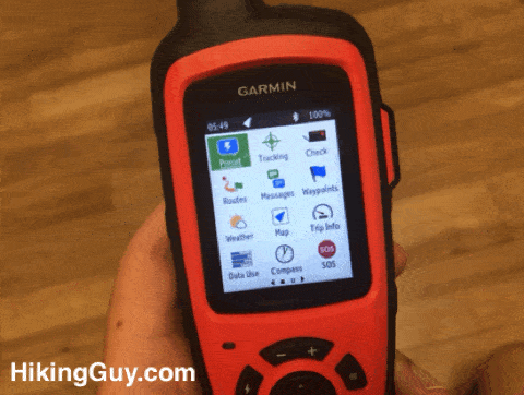
Here's an overview of the functions:
- Preset - send preset messages that you specify on the Inreach website.
- Tracking - track yourself with the built in trip computer.
- Check - check for new messages. If you don't do a manual check, it will check for messages every 10 minutes.
- Routes - follow a route that you've planned online.
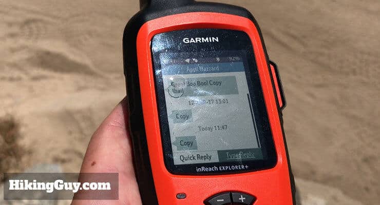
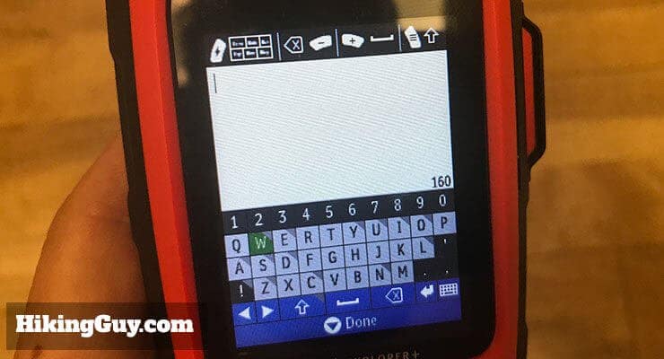
- Messages - a list of your inbound and outbound text messages. You can also send custom text messages from here.
- Waypoints - a list of your waypoints and the ability to add a waypoint.
- Weather - get a weather report for a location. There are two flavors, free and premium (more later).
- Map - an interactive topographic map.
- Trip Computer - stats for your current trip.
- Data Use - check whether your data use is still within your plan.
- Compass - access the compass and some navigation info.
- SOS - launch an SOS from the menu. There's an automatic cancel in case you hit this by mistake.
- Contacts - a list of your contacts that you can sync from the website.
- Location - pinpoint your location with the GPS and share it.
- History - a history of your messages.
- Test - tests the units connection with the Iridium satellite network.
- Settings - tweak a bunch of settings to customize the unit.
Satellite Text Messages
This is the number one reason why I recommend InReach Explorer. The Garmin InReach Explorer is unique in that it lets you send and receive text messages with any cell phone in the world. The other functions are okay, but this is the game changer (and why Garmin probably bought the company from Delorme).
There are a few ways to send messages.
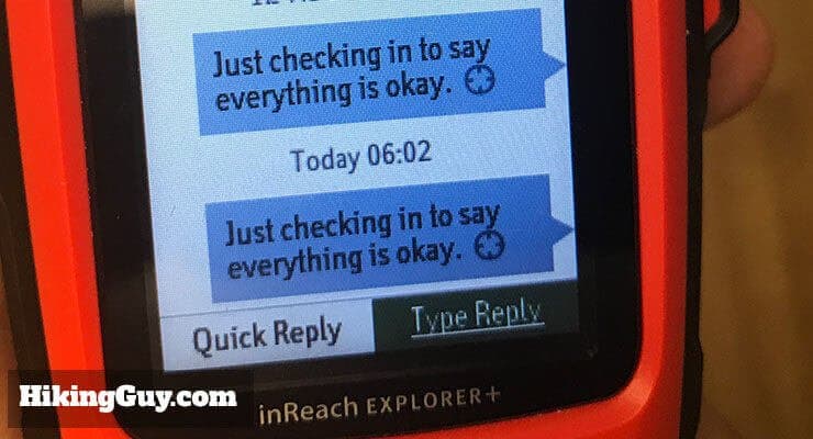
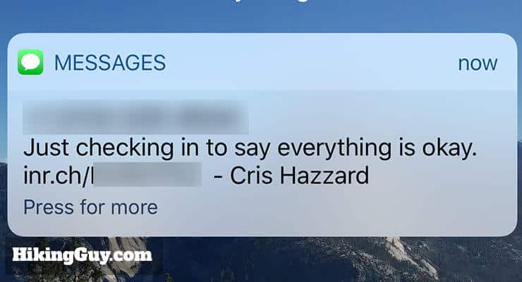
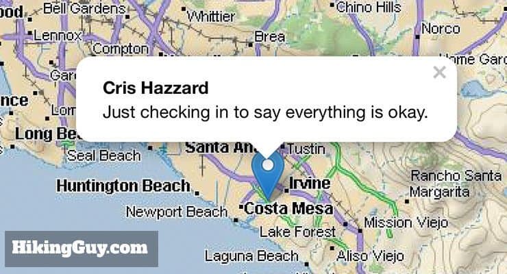
You have three preset messages which are very easy to send from the unit. These are canned text messages to preset recipients that you specify on the website. The nice thing about these preset messages is that you can send as many as you want within all the data plans (more later). You can also attach a link to your position. So I send a lot.
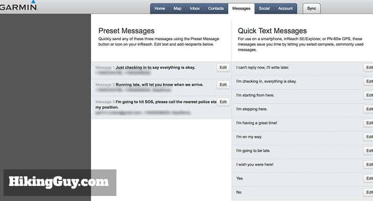
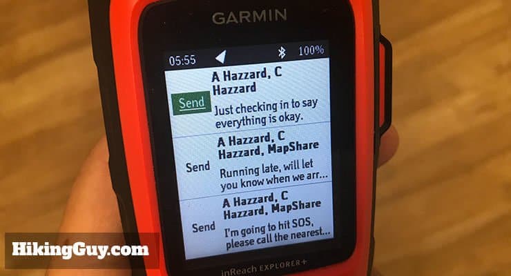
Here's my setup (yours might be different).
- Just checking in to say I'm okay. I fire this off once or twice to my wife when I do a hike, usually when I finish. It gives her peace of mind, especially if I'm doing a hike that's especially challenging, long, or off the beaten path.
- Running late, will let you know when I arrive. Every once and a while a hike runs longer than expected, and I don't want my wife to call search and rescue if I'm not back when I say I will be. This is a simple way to say I'm late. I follow-up with my first "I'm okay" preset message when I finish.
- I'm going to hit SOS, please call the nearest police station with my position. This is for a worse case scenario. I figure that if I hit SOS and I have a family member calling the police station, my family member will be able to give the search team more info about me. I send this message to my wife and a few other family members. The only thing you have to be careful of is hitting this by mistake.
This past week the Explorer+ really came thru. Day one of a Scout 50 miler I became a heat casualty and ended up stuck on the side of a mountain at 5000'. I was able to connect with my wife to let her know I needed to get picked up the next day. It's probably the only gear purchase that I've made that my wife really appreciates. Take the time to read the user manual (PDF) available on Garmin's website. It took a little while but definitely worth it. - REI Reviewer
There's also something called "Quick Text Messages" where you can pre-type a message on the website. It's nice because typing a message with the rocker keyboard is a pain. Quick Text Messages count against your data plan.
A note on the preset and quick text messages. You have to create them on the website before you use the unit, and then sync them to the unit. The sync is a manual operation with your computer, a USB cable, and your unit (more later).
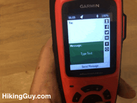
Lastly, you can just do a free-form text message. As I mentioned, it's a pain to type them out with the rocker button and keyboard, but it works. I rarely use this, but it's nice to have. 99% of the time I use the preset messages.
Satellite Performance
The InReach Explorer only sends and receives messages if it has a satellite connection. It uses the Iridium satellite network, which has pole-to-pole global coverage, so it essentially works everywhere.
I was able to receive GPS coordinates on my InReach but not on my iPhone when in a heavily forested area. - REI Reviewer
The antenna does best when it has a clear line-of-sight to the sky, but I've used it in a canopy of trees without problems. Other times cloud cover has made a connection tough. I think it's more a function of satellite technology rather than the unit itself. In general, I can get a satellite and GPS connection within 2-3 minutes of startup. Most message sends happen in 2-5 minutes.
Sometimes it takes a few minutes more, even with a clear line of sight. It does seem to connect quicker than the old Delorme InReach though, but this is just an observation.
A great feature of the device is that it will continue to try and send the message even if it doesn't have a message. So I usually just send it, hike, and I get a distinctive beep when the message goes through.
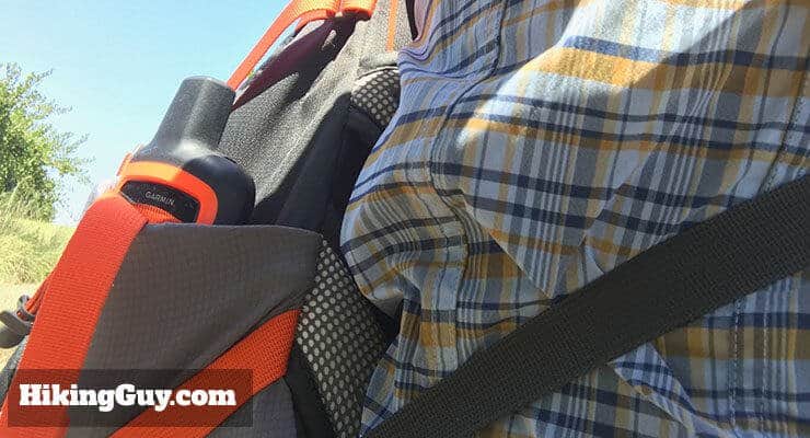
Garmin recommends mounting it on the top of your pack or upper body.
Emergency Beacon
The SOS beacon is the number one reason why I chose this unit. Well, maybe this and the text messages. There's not a lot to say here, I think you probably figured it out already. The InReach uses the same Iridium satellite network to send distress signals.
When do you know that it's okay to hit SOS? Read this.
There are two ways you can send an SOS.
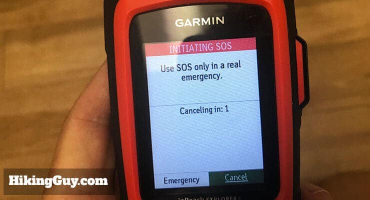
Here's how the SOS emergency beacon works. Garmin has teamed up with GEOS, which handles the actual emergency communications. When you trigger an SOS, GEOS gets a message with your GPS position. They will also get access to the data associated with the device, which includes a little bio you can fill out that describes you.
GEOS has a database of all the first responders in the world, and they will contact the appropriate agency and coordinate a response. They will also message you back on the device (not confirmed!) and keep in contact with you. This is a key differentiator from other (one-way) emergency beacons (aka PLB, personal locator beacon). For example, if you need to perform immediate actions (such as first-aid), GEOS can advise using text messages.
Already used it in the Alps and in the Costa Rica jungles. Communicates well and your location as well as any additional messages are transmitted as promised. - REI Reviewer
This emergency coverage works all over the world and even in the middle of the oceans (which is why it's a good option for sailors too). GEOS has coordinated rescues in over 140 countries. It makes you want to just keep this thing with you all the time, just in case.
Garmin has a rescue story up on their blog here, which will give you an idea of what a rescue looks like. Also, note that the rescue took 21 hours. Hitting the SOS button doesn't send a chopper within 30 minutes. A rescue can often be many hours and can happen on foot. Expect at least 6 hours.
You must use the SOS button with care. While devices like the Garmin InReach are great for hikers like us, a lot of SARS (search and rescue) responders aren't big fans. Why? Because people use them when it's not a real emergency. I've heard stories of folks hitting the button when they are nauseous, have a sprained ankle, etc. When you hit that SOS button, you immediately put the entire SARS team lives' in danger. You need to weigh the situation carefully before you hit SOS. If you can evacuate yourself, do it. I highly recommend a wilderness first aid course, which for a small investment of a weekend, will give you the skills to potentially save lives (including your own). It will also educate you on when to signal for a rescue.
Rescue Insurance
Another great thing about the InReach is that you can opt into some reasonably priced search and rescue insurance plans. These are 100% optional, and you can opt-in from your InReach account webpage and dashboard.
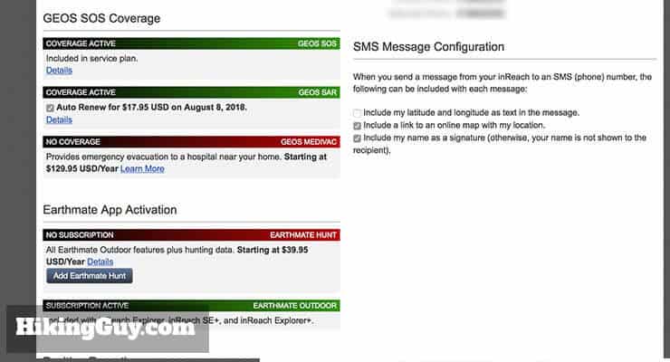
The first option is GEOS Search and Rescue insurance. It costs $25/year, and gives you $100,000 of rescue insurance during life-threatening emergencies alerted with your InReach Explorer. So if you have a stomachache and call for help, you're paying for it yourself. It covers you worldwide, except for a few countries (don't hike in Syria). There are some exclusions, such as pre-existing conditions, so read the terms before you signup.
Note that since Garmin acquired GEOS, they no longer offer the medical evacuation insurance option.
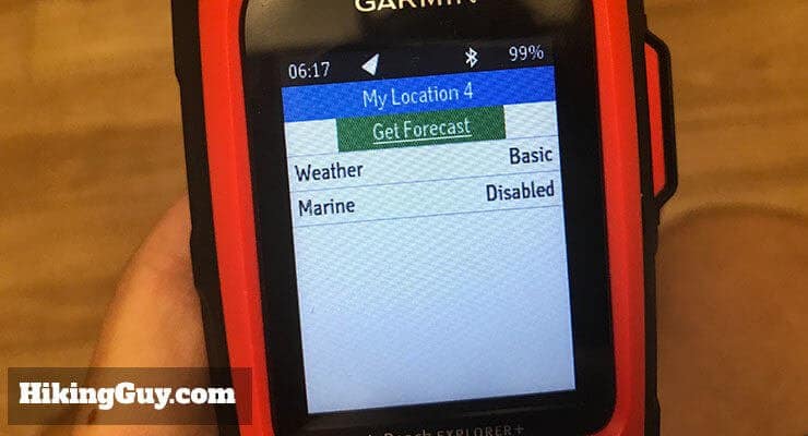
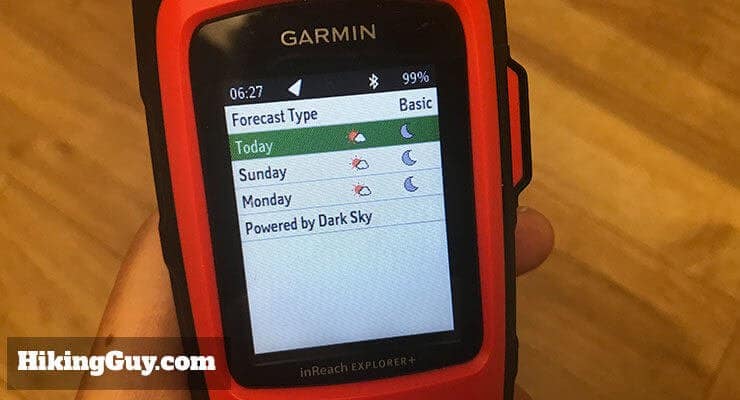
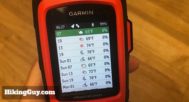
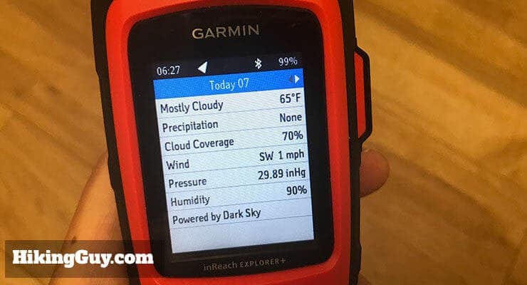
Weather Reports
One of the great new features that Garmin added to the InReach Explorer is weather reports. The weather reports work through a text message and are powered by DarkSky (in the USA at least). DarkSky specializes in hyper-local weather forecasts, and they also have a very cool app for smartphones. On the InReach Explorer, the weather report is a little more basic (but still very useful).
I just go back from a successful Denali expedition and my inReach Explorer+ worked very well for unlimited texting whether tethered to my phone or not. The GPS worked pretty well for 10-minute interval tracking although it did record a lot more spurious off-track points than my Garmin GPSMap does in wide open areas where it shouldn't. I saw a lot of other teams with this model and expect it is on the way to replacing more expensive and heavier satellite phones. - REI Reviewer
For most hikers, you should be checking a detailed weather report before you hit the trail. But the weather can change, even on a day hike. I find the weather most valuable on multi-day hikes, especially in the mountains. I used the weather texts on backpacking trips in the Sierras and on Catalina, and it was great. I could see an hourly weather report with temp and chance of precipitation. So it was pretty easy to see if there were thunderstorms predicted for the afternoon, and I could make sure I wasn't on a summit or somewhere risky when that happened.
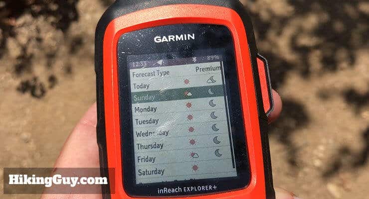
There are a few flavors of weather reports.
- Basic (free)
- 3-day forecast displayed in 6-hour intervals.
- Stats
- Cloud cover
- Temp
- Precipitation
- Chance of
- Precipitation
- Wind
- Barometric Pressure
- Humidity
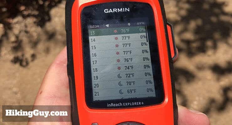
- Premium ($1.00 per request)
- Same stats
- 7-day forecast displayed in varying intervals (1-2 hour intervals for the first day, 3-6 hour intervals for the next day and 12-hour intervals for the remaining 5 days).
- Marine ($1.00 per request)
- Activated when your position is over water
- Same stats in the Premium forecast
- Wave height, ocean current, and visibility details
- Based on OCENS premium marine weather data
You can choose between basic, premium, and marine on the go, which is helpful. Thank you Garmin for not locking us into an expensive subscription here.
Topo Maps, GPS, and Navigation
Just a reminder, there are two models of the Garmin InReach, the SE and Explorer. The InReach Explore+ has topo maps, built-in digital compass, barometric altimeter and accelerometer. The SE just uses GPS for navigation functions, so you have to be moving for it to guesstimate your direction.
If you're looking for a good mapping and navigation unit, don't buy the InReach. With a little time, you can learn how to navigate with it and make it work, but it's clunky and you'd be better served by using other units like a Fenix or eTrex (or even GaiaGPS and your phone). Spend the extra $50 on the InReach Explorer so that you have some map and navigation backup tools in case your other GPS fails, the batteries die, etc.
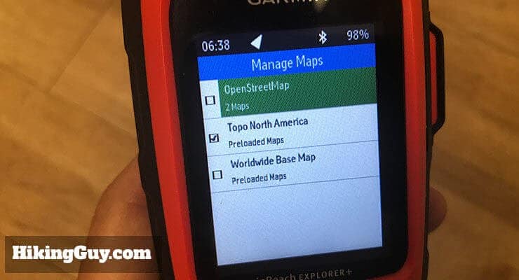
Here's the lowdown on the maps that come with the InReach Explorer. Note that the maps are not available on the InReach SE.
- The Explorer sold in North America comes preloaded with USA, Canada, and Mexico topo maps.
- The USA and Canada maps are 1:24k scale.
- The Mexico map is 1:125k scale.
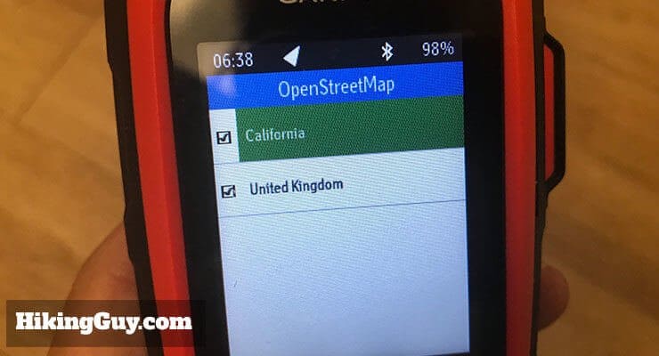
- Units sold in other parts of the world will have maps associated with that region preloaded.
- The maps are NOT Garmin maps; they are Delorme maps. The Delorme maps are not as good for hiking as Garmin or OpenStreetMaps, but they do have a decent amount of topo detail and roads. Enough to use in a pinch.
- You can load other worldwide maps from the InReach website onto the device. They include some OpenStreetMaps, but not the ones tailored to hiking. They still have good detail, and I image Garmin might add more flavors in the future.
- You can also pay for and load hunting maps on the InReach website. I have no idea what they give you, but if it's important to you, they're there.
- You can customize the map display in settings.
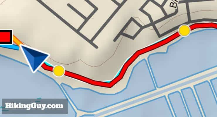
- If you want to create a route on the map, the InReach won't route you on trails or streets; it will create a straight line between you and your destination.
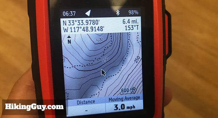
- You can move the pointer around the map to get a lat/lon, elevation, distance, and bearing.
Absolutely glad that I purchased this unit and would purchase again. Just don't expect a lot out of the GPS mapping and tracking features. - REI Reviewer
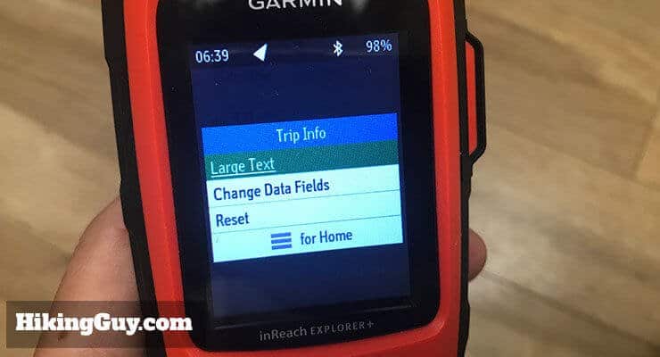
At the most basic level, you can use the "trip info" screen to give you key navigation information. It covers most of the standard info like distance, time, speed, time, etc. A nice aspect of the "trip info" screen is that you can customize the data fields and field size. The number of data fields is not as robust as other Garmin devices. For example, it doesn't give you elevation climbed, just current elevation. And the InReach can't connect to Garmin sensors like a heart rate monitor, foot pod, VIRB camera, etc. to offer that information.
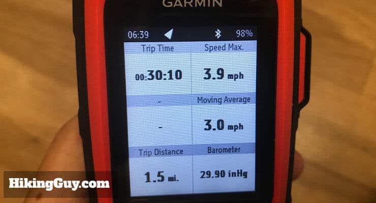

If you have the InReach Explorer, you can display the digital compass, which will give you a bearing even if you're standing still. You can also display the barometric pressure, which is handy to keep an eye on the weather. If the barometric pressure is going down, the weather will get worse (and vice versa). If it's changing quickly, the more quickly the change will occur.
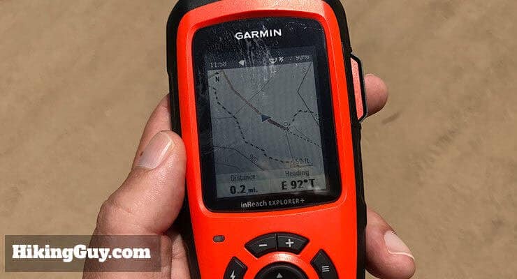
You can mark waypoints and navigate them on both units, that's pretty straightforward. The advantage on the InReacher Explorer is that you can use the map to browse and mark waypoints, while on the SE you cannot. You can also mark waypoints by entering a lat/lon. For all waypoints, you can navigate to them (in a straight line). The unit won't route you along trails or streets, just a straight line.
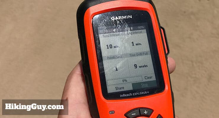
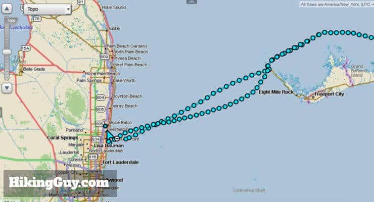
There's a feature called "tracking" that's a little different that a normal Garmin GPS track. On the InReach, tracking means recording your track and transmitting tracking points to a web page that plots the points on a map. There are a few tracking intervals that you can set. First is the "send interval" which specifies how many times the InReach will broadcast your position to the tracking website. And then there is the "log interval" which is how many times the InReach will take a GPS fix and plot it on the unit. There are also options such as "extended tracking," "auto tracking," and "burst mode." Check out the online manual for specifics. Last Depending on your plan, you may have to pay for each time it sends your location (a location ping measured by the "send interval"). Note that tracking and transmitting drains the battery more than not doing it.
The track on the inReach is not as useful as it is on other GPS units. On units like the eTrex, you can see a track and double back on it. Here, it gets transmitted out, you can view it on the screen. and that's it. The sales information for the InReach says you can "follow a breadcrumb trail back to base" but I cannot for the life of me find out how to do this, and the manual doesn't mention me. The only thing I can assume is that you can do it visually by looking at your recorded track and then follow it.
Tip: Change your track color to red in the map settings so you can see it better.
You can also create routes to follow. First off, you have to do this on the InReach website and sync the route to your device. And second, unlike other units that route you along a trail, here you plan your routes manually, point by point. So if a trail twists and turns 20 times in a mile, you are creating 20 points on that route. Not very practical. The website allows you to import a GPX track from elsewhere, but again, it's a lot of hoops to jump through to complete a simple task. You can't create routes on the unit or a paired phone, although you can mark waypoints on either (and then navigate to them).
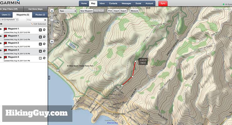
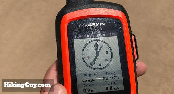
When you have a route in the InReach and you want to follow it, it only gives you a straight line bearing and distance to the next point on the route (think of a route as a collection of sequential waypoints). The unit will not alert you when you need to turn like the eTrex will. The best screen to follow routes from is the compass screen.
To sum it up, I wouldn't use this unit to navigate. Get the maps and extra tools on the Explorer as a backup navigation tool. It's $50 more and that's it. The unit is otherwise the same (weight, dimensions, etc.)
I bought the InReach right before our trip to Mt San Jacinto peak. On our way up most of the trail was unmarked and had more snow than we thought. On the way down we lost the trail but luckily we had this wonderful piece of gear to get us back on the trail. Best piece of gear I own today. I can see this saving someone's life in a hard time. - REI Reviewer
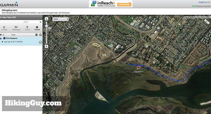
Sharing Your Position
If you want to share your position in real-time with others, the Garmin InReach is great. You have to pay for tracking in your data plan, but you can get unlimited tracking for a few bucks a month. You can customize your tracking interval and sharing interval from 1 minute to 4 hours.
The technology itself worked flawlessly and allowed easy two-way communication plus pinpoint accuracy on my son's location updated every 30 minutes. As a safety and tracking device this technology and in particular this unit is perfect. It's not inexpensive, but when it comes to safety I think it's worth every penny. - REI Reviewer
People can follow your progress through the Garmin web portal, which you can setup and customize. You can password protect it, customize the display, and even allow viewers to message you through the portal. When you start tracking, you are also prompted to share your new track with friends (on the InReach device), which you can also opt-out of. If that wasn't enough, you could also publish to Facebook and Twitter.
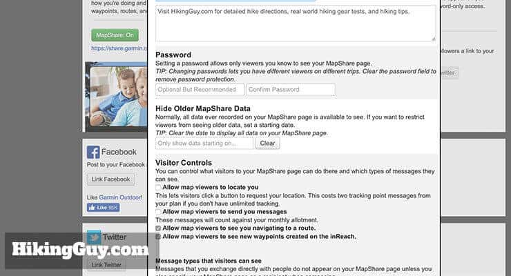
Overall, I think this sharing feature is very cool, but I never use it. I could see this coming in handy for an expedition where you want to interact with an audience. But for me, it's overkill. I simply include a link to my position in my preset messages like "I'm okay just checking in" and that works fine. And it doesn't require the extra costs for data tracking.
Not sure if InReach is up? You can check the status of the InReach system here.
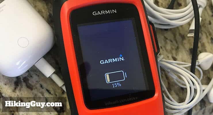
Battery Life
Overall, the battery performs well but has some limitations. Garmin lists the battery life as:
Up to 100 hours at 10-minute tracking mode (default); up to 75 hours at 10-minute tracking with 1-second logging; up to 30 days at the 30-minute interval power save mode; and up to 3 years when powered off
My experience has been pretty consistent with that. With 30 minute tracking, two text msgs per day, and unit off at night, a full charge lasts about 6 -7 days. If you just power the unit on to send an occasional preset message, the unit lasts months without a charge. That's typically how I use it. If I'm on a remote or long hike, I'll fire it up a few times to send an "I'm okay" preset message and then turn it off. That way if I do have an emergency, I'll have plenty of juice to run the thing with back and forth text messages.
This is a robust, reliable satellite communicator and GPS orienteering device all in one package with the ability to last 100 hours on a charge if used responsibly. That should end the discussion. In my thinking, everyone who drives out of cell coverage should have one of these with a minimum subscription plan if only to be able to summon help if the car brakes down. - REI Reviewer
There are a few options to extend the battery life, and it's very customizable. You can set a longer tracking broadcast interval, diminish the screen brightness, and turn off bluetooth.
The limitation of the device is that the rechargeable lithium battery is internal, so you can't buy another, you can't swap it out, etc. I really wish Garmin created the unit so that you could swap another rechargeable lithium battery into the unit. That would extend it's usefulness for many folks.
However, the problem is not a tough one to solve. Just buy any old external battery charger that works on USB (like the ones used to charge phones) and you'll be fine.
Phone Connection
Another neat feature is that you can sync the Garmin InReach with your cell phone. I don't use this function much but it comes in handy for some people, especially the texting part (since you can use the phone keyboard). The simple way to think of it is as a remote controller for the InReach unit. It uses bluetooth to get the GPS, message, and sensor data from the InReach, and then displays them on the phone (with maps).
Here's a lowdown on how it works.
- You install the free Earthmate app on your phone (iPhone and Android).
- You have to pair your phone to the InReach using Bluetooth.
- You can read the GPS position and data from the InReach unit and display them on your phone.
- You can download additional maps in the Earthmate app and plot your position on them. This is a handy feature, especially if you only use the InReach SE that doesn't have build in maps.
- You can start and stop tracking and navigation from the phone. The phone map display actually shows your track line too.
- You can send and receive messages using your phone. This is generally much easier because you can type on your phone's keyboard. It also can access your phone's contacts so you can text to them.
- You can view the compass.
- You can view routes and waypoints, and you can start navigation to them.
- If your phone has a cell connection, routes and waypoints will be synced from the InReach website to the phone.
Personally, it's too much to have the phone and InReach connected. It doesn't really offer me much and drains both batteries (the InReach and the phone). I appreciate having the ability to do it in the case of an emergency though. If I needed to do a lot of back and forth messaging with a GEOS rescue coordinator, I'd probably fire the phone up so that I could type quicker.
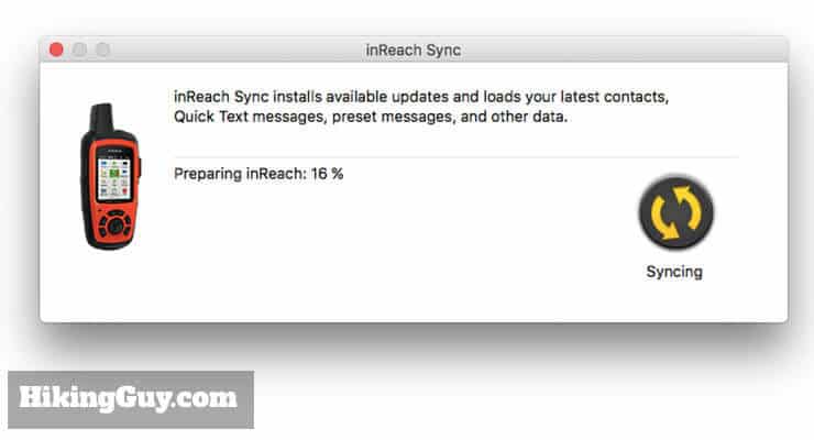
Syncing The InReach
One of the requirements to use the Garmin InReach is that you have to have a computer to sync it and set it up with. The process is pretty simple, you just download the InReach Sync program, connect your device with a USB cable, and sync. You will need to sync with the cable to update the unit's firmware and sync additional maps. It will also sync waypoints, messages, contacts, and routes.
The Earthmate phone app also has limited syncing capabilities. If your phone has a data connection, it will pull the waypoints and routes from the InReach website and sync them with the device.
Using It On the Trail
One of the great things about this device is that it's rugged. It feels beefy, and has a rubber "bumper" that surrounds it. You can drop it, get it wet, whatever, and it works. It's IPx7 rated, so it's built to get wet and dirty (but not submerged deep underwater).
The screen is bright and easy to read from almost any angle (and starts to become unreadable at about 145 degrees).
I comes with a carabiner clip so you can attach it to your pack. I usually carry it in a side pocket of my pack, but it can easily fit in most pants pockets too.
Garmin InReach Or Other Options?
Garmin InReach vs Spot Messenger
I used to love my SPOT messenger. It was a revolutionary piece of gear when I got my first one in 2010. It is similar to the InReach in that it allows you to send an SOS, send (1) custom message, send an "I'm okay" message, and send tracking points. You could put AAA batteries in it or recharge with USB. It's much cheaper than the InReach, at around $150 + subscription. I used mine for years but abandoned it because there are better options out there (like the InReach).
Here's why I don't use the SPOT.
- The main reason is that it's unreliable. Often "I'm okay" messages wouldn't go out until hours later. It was generally okay given the hours I used it, but I want to be 100% sure it will work in a survival situation, and I couldn't with the SPOT. I had an original SPOT and a SPOT 3. The SPOT 3 was a little better but died in a rain storm.
- The SPOT doesn't let you receive messages. You have no idea if someone got your SOS or text.
- There are no other navigation functions on the SPOT.
- The SPOT doesn't offer a freedom plan, you have to lock into an annual term.
- They have horrible customer service.
- Other folks have had a hard time canceling their subscription, and SPOT evidently auto-renews without notifying you first, locking you into another year if you forget about it.
If you're on a strict budget, it's better than nothing. But just remember, you could be saving money at the expense of your life.
Don’t fool around with the weak “Spot”, the rescue pilots I know quickly convinced me that ACR was the way to go. - REI Reviewer
Garmin InReach vs ACR ResQLink
So I actually hike with both the Garmin InReach and the ACR ResQLink, with the ACR ResQLink being my backup emergency beacon.
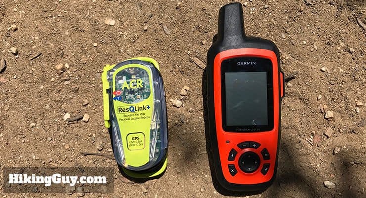
The ACR ResQLink is a little different in some important ways.
- The ResQLink has no two-way communications or navigation screens. In fact, it doesn't even have a screen.
- The ResQLink is a pure emergency beacon. It does one thing, and one thing well. You press the SOS button and it alerts search and rescue.
- It's built to industrial standards.
- It requires no subscription fee.
- It works on a different communications system than the InReach (which uses Iridium satellites). The ResQLink uses the 406 MHz SARSAT COSPAS system, which is an entirely different system than the one that the InReach uses. Instead of being plugged into GEOS for search and rescue management, you are plugged into the US Air Force search and rescue on land in the USA (and Coast Guard if offshore).
- It also works worldwide and will notify the appropriate search in rescue team in the country you activate it in.
The ResQLink not only gives me an emergency backup, but also works on a whole different system in case Iridium / GEOS is not working for whatever reason. Does it cost a few hundred bucks to carry both? Yes. Is it much heavier? It's about 5oz, which is the weight of a baseball. Is my life worth it? Yes. Yes. Yes.
You can check out my review of the ACR ResQLink here.
Other Options
You could also get a satellite phone. In general, they're expensive, and the plans are very expensive. There's also a unit called the Iridium GO, which is a mobile satellite WiFi hotspot, so you can connect your smartphone and signal for help that way. That option is also expensive. If you already have one of these devices, you can probably just hike with that. Otherwise, I'd get something like the InReach, which is tailored towards hikers and the outdoors.
What Could Be Better on the InReach
While the InReach is great, there is room for improvement. I think this product will evolve, and this first Garmin unit is an incremental evolution from the Delorme version.
- The InReach isn't integrated into the Garmin ecosystem of products. It has its own website, you need a different sync program than all the other Garmin programs, you can't use Garmin Basecamp to plan hikes, and you can't use Garmin maps.
- The interface is a little clunky and old-school. It's not really a big deal, but you feel like you went back to 2006 when you use it.
- It falls short as a navigation tool. I'd imagine that the next generation of units will combine the best navigation features of other Garmin GPS units with the satellite messaging on the InReach.
- The phone and Earthmate app should allow you to sync more things, such as preset messages, routes, maps, etc. The unit would be so much more useful if you could plan a route on a routable map on your phone or tablet, send it to the device, and then get navigation alerts when you need to turn.
- The positioning only offers GPS, no GLONASS (like many other Garmin GPS units). Not a huge deal.
When I look at the bad reviews for the unit, they generally fall into two buckets.
- People who have problems setting it up or syncing it, which could arise from a number of causes.
- People who buy it thinking that it's as good as other Garmin GPS units for navigation.
For me, the positives greatly outweigh the negatives.
Should You Get the InReach Explorer?
The Garmin InReach is the only way to have a two-way conversation with friends, family, and rescue services (unless you pay a few thousand for a sat phone and plan). It's not only a great way to let people know your safe, it's a great way to share your adventures, and of course, a great way to signal an SOS that could save your life. That's why I always carry the Garmin InReach. If you're on a tight budget, just get the InReach SE. If you can afford another $50, opt for the maps and enhanced sensors in the InReach Explore. In an emergency situation, they're a great asset to have.
If you’re thinking about buying the Garmin InReach, there’s something important you can do to help support this site. Click on the link below to buy your InReach from REI. You get REI dividend money back, free shipping, you can easily return it, and there’s a host of other benefits. I get a small percentage of every sale, so you’ll help support my website hosting costs and all that dumb stuff.
Latest Garmin InReach Prices and Reviews
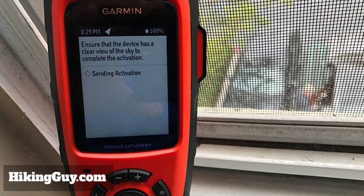
Setting Up Your Garmin InReach
A lot of people seem to have negative reviews of the configuration but for me it was nothing short of smooth and perfectly operational within a few short steps. Is it highly configurable? Yes. This is not a device that you leave as is. You customize and configure the maps, waypoints, routes, comm settings as you see fit. - REI Reviewer
Setting up your InReach unit takes a little time. Block off an hour to go through all the steps. And the more time you spend using the unit and understanding the features up front, the more you will get out of it on the trail.
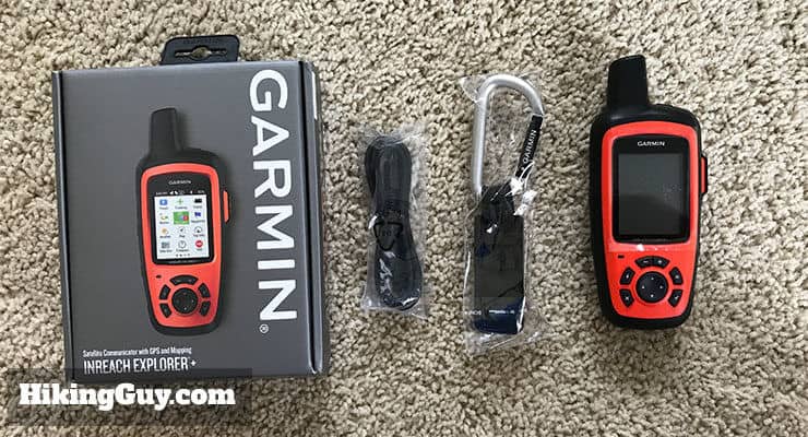
And another reminder, you need a computer, internet connection, and subscription to make the unit work. You can't just take it out of the box, fire it up, and hit the trail.
I also recommend checking out the online manual.
If you have any questions or get stuck, I recommend:
- Posting in the Garmin Forums
- Posting on the Garmin Reddit board
- Contacting Garmin support
- Checking the InReach System Status
Need More Info?
- Have a question about the guide? Join my Patreon and ask me a question.
Related Guides
 Garmin GPSMAP 66i Review & Guide
 In-Depth Garmin Montana 750i, 700i, 700 Review
 Hiking Gear & Outdoor Technology
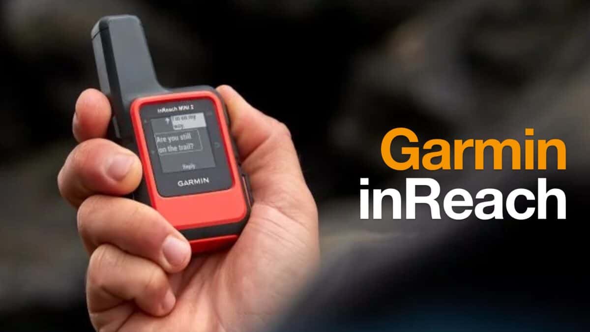 Garmin inReach
Popular Guides
 Best Hiking Gear 2024
 Hiking Boots or Shoes: Do I Really Need Hiking Boots?
 When to Hit SOS on inReach
This Guide Was Written by Cris Hazzard

Hi, I'm Cris Hazzard, aka Hiking Guy, a professional outdoors guide, hiking expert, and author based in Southern California. I created this website to share all the great hikes I do with everyone else out there. This site is different because it gives detailed directions that even the beginning hiker can follow. I also share what hiking gear works and doesn't so you don't waste money. I don't do sponsored or promoted content; I share only the gear recommendations, hikes, and tips that I would with my family and friends. If you like the website and YouTube channel, please support these free guides (I couldn't do it without folks like you!). You can stay up to date with my new guides by following me on YouTube, Instagram, or by subscribing to my monthly newsletter.